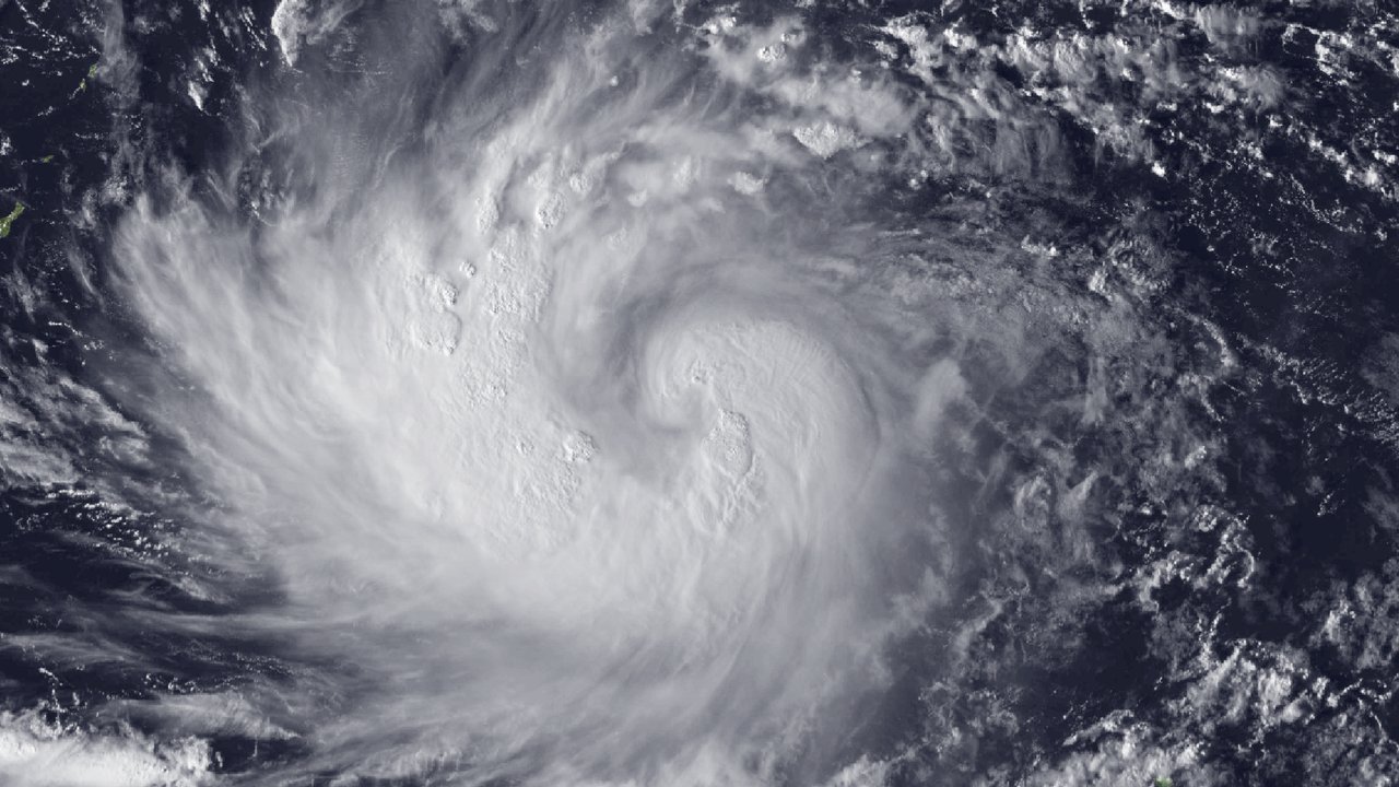
Typhoon Champi grew into a Category 2 storm on Saturday afternoon, Guam time, as the U.S. territory entered its highest storm-readiness level, according to the National Weather Service (NWS) office in Tiyan, Guam, and Guam’s Joint Information Center (JIC). In Advisory No. 11, issued at 1:06 PM ChST Saturday, Oct. 17 (8:06 PM PT Friday, Oct. 16), the NWS placed Champi’s center about 225 miles east-southeast of Guam at 1:00 PM ChST, moving west-northwest at 18 mph. The advisory says: “Maximum sustained winds have increased to 100 mph, which now makes Champi a Category 2 typhoon.” It still expects a slight turn toward the west with a slight decrease in forward speed, and says that track “will take Champi just south of Guam as a Category 3 typhoon.”
The storm also seems to have grown wider. Advisory No. 11 puts typhoon-force winds up to 40 miles from the center and tropical-storm-force winds up to 125 miles, compared with 30 and 100 miles in Intermediate Advisory 10A, issued at 10:44 AM ChST, about two and a half hours earlier. A Typhoon Warning remains in effect for Guam, Rota and the adjacent waters, and Tinian and Saipan remain under a Tropical Storm Warning and a Typhoon Watch, according to Advisory No. 11, which says typhoon conditions, including winds of 74 mph or more, should arrive by Sunday morning, with tropical-storm-force winds arriving Saturday night. The NWS scheduled an intermediate advisory for 5:00 PM ChST (midnight PT) and its next full advisory for 8:00 PM ChST (3:00 AM PT Saturday).
Gov. Lourdes A. Leon Guerrero placed Guam in Condition of Readiness (COR) 1 as of 1:00 PM ChST Saturday, according to JIC Release No. 7 from Guam Homeland Security and the Office of Civil Defense (GHS/OCD), posted at 1:00 PM ChST. The release tells residents: “Remain indoors until COR 4.” It says Joint Region Marianas and its installations would move to Tropical Cyclone Condition of Readiness (TCCOR) 1 at 3:00 PM ChST (10:00 PM PT Friday). The release expects Champi to pass either just south of Guam or over southern Guam late Saturday night into Sunday morning as a Category 3 typhoon, which it defines as 111 to 129 mph sustained winds with possible gusts of 140 to 164 mph. It advises southern villages to evacuate from coastal, flood-prone areas, and it warns: “Life-threatening, heavy coastal inundation is expected.”
The release also moves the timing. JIC Release No. 7 says conditions should begin to deteriorate by noon Saturday, with damaging winds of 39 mph or more expected by early evening, and typhoon-force winds of 74 mph or more beginning as early as 6:00 AM ChST Sunday (1:00 PM PT Saturday). The JIC’s earlier Release No. 5, posted at 9:45 AM ChST and covered in this desk’s previous Champi story, had given 5:00 AM ChST Sunday for that threshold. Release No. 7 says everyone must sit in a safe shelter before sunset on Saturday and remain indoors in a secured, concrete-reinforced shelter, and that the All Hazards Alert Warning System (AHAWS) sirens will broadcast emergency alerts and instructions during the storm.
Officials and forecasters seem to differ on how much of Guam takes the full force. Release No. 7 states: “All of Guam will experience Category 3 typhoon force conditions”. The Pacific Daily News, in a 1 p.m. update by Julianne Hernandez posted at 12:58 PM ChST, reports a more graded outlook from Landon Aydlett, the NWS warning coordination meteorologist, at a weather briefing just before noon Saturday: Category 2 conditions across much of the island, and Category 3 winds islandwide if Champi passes directly overhead. If the storm tracks south, the paper reports, southern villages could take the worst of the winds and rain, while central and northern Guam could see Category 1 or Category 2 conditions; Aydlett called Category 1 in the north and Category 2 in the south a reasonable best case. This desk has not reconciled the two outlooks; the briefing came about an hour before the release.
Aydlett also warned that the south faces a harder hit than in recent storms, the Pacific Daily News reports. “This is going to be a significant strike to the island of Guam Sunday morning,” he said. He also said: “Just south of southern Guam, they will see in those southern villages Category Three typhoon force winds that will exceed their impacts from Typhoon Mawar back in 2023,” according to the paper. The paper reports he said southern Guam had tropical storm to Category 1 conditions during Mawar, and that impacts on Guam could exceed those from Typhoon Mawar, Typhoon Bavi and Tropical Storm Choi Wan. He added that even a track south of Guam would not spare the island, because the typhoon-force wind field could extend as far as 35 miles north of the center, and that a shift of 10 miles could make a significant difference for individual villages.
Forecasts of peak strength keep climbing, by the sources’ own figures. Aydlett said forecast winds near closest approach had risen from 110 mph the previous day to 125 mph, according to the Pacific Daily News; forecasts called for sustained winds of 125 mph at the storm’s closest approach, expected between 6:00 and 8:00 AM ChST Sunday (1:00 to 3:00 PM PT Saturday), and a later forecast graphic showed 120 mph as Champi approached Guam and 140 mph as it departed. Aydlett said a strengthening to Category 4 before arrival remained possible but not expected, and warned that explosive rapid intensification over the next 12 to 18 hours could produce a stronger storm than forecast, the paper reports. The Joint Typhoon Warning Center (JTWC), in Warning No. 11, gives 85 knots gusting to 105 at 10:00 AM ChST Saturday (5:00 PM PT Friday), with a minimum central pressure of 981 millibars, and forecasts 100 knots gusting to 125 at 10:00 PM ChST Saturday and 115 knots gusting to 140 (about 132 mph sustained, by this desk’s conversion) at 10:00 AM ChST Sunday, near 13.4N 143.7E. JTWC forecasts a peak of 135 knots gusting to 165 by 10:00 AM ChST Monday, near 14.8N 139.5E, a position this desk reads as well west of Guam. JTWC gives its maximum winds in knots, based on a one-minute average.
The timeline for Guam runs through Sunday, according to Aydlett as the Pacific Daily News reports it. Tropical-storm-force winds above 39 mph could begin as early as 9:00 PM ChST Saturday (4:00 AM PT Saturday), most likely around midnight, then intensify overnight. He said the strongest typhoon conditions could last roughly from 4:00 AM to noon Sunday, that tropical-storm-force winds should pull away around 10:00 PM Sunday, and that residents should avoid focusing on a single closest-approach time. He put the probability of typhoon-force winds on Guam at about 60% to 80% and said it could rise. The paper reports the storm should move through the region quickly rather than linger for two or three days, though Aydlett said that would not lessen the impact.
Aydlett also addressed rain and coastal water at the briefing. He said Guam could receive 12 to 20 inches of rain, with 16 to 20 inches possible beneath the eyewall on a track near southern Guam, and also described an estimate of 12 to 18 inches for the event, according to the Pacific Daily News. He said water could rise 5 to 7 feet above normal levels, pushing water, rocks and gravel onto normally dry land, a range above the 3 to 5 feet of coastal inundation in the NWS local statement issued at 9:13 AM ChST, the latest local statement this desk could retrieve. “Deadly conditions out there,” Aydlett said of the seas and surf, the paper reports. It adds that a special marine warning covered a Doppler-indicated waterspout southeast of Guam. JTWC’s Warning No. 11 gives a maximum significant wave height of 34 feet at 10:00 AM ChST Saturday, a figure for the storm’s seas rather than the coast.
Shelter options grew on Saturday. JIC Release No. 7 says the Guam Department of Education would open a sixth emergency evacuation center, Inalåhan Middle School, for the southern region, ready to receive residents at 2:00 PM ChST (9:00 PM PT Friday); the release lists its capacity as TBD, alongside the five centers already open. The release says the Southern Region Community Health Center will treat minor, non-life-threatening injuries and basic urgent care needs, and that oxygen-dependent residents must bring their own oxygen concentrators or tanks. Aydlett said residents without reinforced concrete homes, including a reinforced concrete roof, should go to a secure shelter before sunset, and that tents, canopies, tarps and wooden shelters would not protect people from typhoon-force winds, the Pacific Daily News reports. He also warned that a sudden calm during an eye passage would not mean the storm had ended.
No source this desk read reported injuries or damage on Guam; Champi’s closest approach, early Sunday local time (Saturday afternoon PT), still lay ahead when these products went out. Reading note: this desk wrote from NWS Guam Advisory No. 11 and Intermediate Advisory 10A, the 9:13 AM ChST NWS local statement, JTWC Warning No. 11, GHS/OCD JIC Release No. 7 and the Pacific Daily News 1 p.m. update, not field reporting. The JIC release and the NWS briefing reported by the paper describe different impact outlooks from the same forecast cycle, and both may change with the next advisory. Residents should follow the NWS in Tiyan and GHS/OCD, not this summary.
